GRENVILLE COUNTY HISTORY
"Indigenous Children Used to Play"
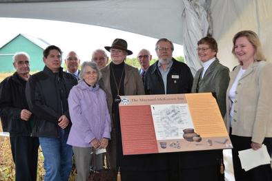
Long before Grenville County was given this name, approximately 500 years ago, it was occupied by a native population. The St. Lawrence Iroquois lived in longhouses in agricultural communities with some of these sites containing as many as 1600 people. Two important archeological excavations have been done in Grenville County, one in 1974 in Roebuck, and one in 1987 in Maynard (Maynard-McKeown site) where much was learned about these early native tribes. The natives were farmers growing corn, beans, squash, sunflowers, and tobacco, sometimes fishing for food and hunting on a smaller scale. A few smaller digs (Cleary site near Spencerville and Crystal Rock site) have been done over the years in the county.
French, then British Occupation
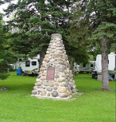
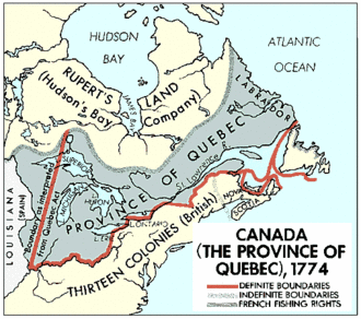
The French also occupied Grenville County with explorers and fur traders passing through this area en route to Fort Frontenac (Kingston) to meet the Indian hunters and trappers. The French built a supply depot at La Galette (Johnstown) in the 1670s and a shipyard and star-shaped fort at Pointe au Baril (Maitland) in 1758, with the ships, the Outouaise and the Iroquoise, being built there. France and Britain were competing for control of the St. Lawrence River area and this broke out into a full-scale war in the 1750s. As the French troops were withdrawing to Quebec, they levelled the fortifications at Pointe au Baril so it would be of no use to the advancing British troops. Before long, the French decided to build new fortifications that would prevent attacks from the west, and they built a fort in 1759 on Isle Royale (Chimney Island) called Fort de Levis (Johnstown area). It was here that the last battle in North America between English and French troops took place in August 1760. In 1763 under the Treaty of Paris, French control was given to Britain, and New France was renamed Quebec. It was incorporated as the Province of Quebec by the Quebec Act of 1774.
Long before Grenville County was given this name, approximately 500 years ago, it was occupied by a native population. The St. Lawrence Iroquois lived in longhouses in agricultural communities with some of these sites containing as many as 1600 people. Two important archeological excavations have been done in Grenville County, one in 1974 in Roebuck, and one in 1987 in Maynard (Maynard-McKeown site) where much was learned about these early native tribes. The natives were farmers growing corn, beans, squash, sunflowers, and tobacco, sometimes fishing for food and hunting on a smaller scale. A few smaller digs (Cleary site near Spencerville and Crystal Rock site) have been done over the years in the county.
French, then British Occupation
The French also occupied Grenville County with explorers and fur traders passing through this area en route to Fort Frontenac (Kingston) to meet the Indian hunters and trappers. The French built a supply depot at La Galette (Johnstown) in the 1670s and a shipyard and star-shaped fort at Pointe au Baril (Maitland) in 1758, with the ships, the Outouaise and the Iroquoise, being built there. France and Britain were competing for control of the St. Lawrence River area and this broke out into a full-scale war in the 1750s. As the French troops were withdrawing to Quebec, they levelled the fortifications at Pointe au Baril so it would be of no use to the advancing British troops. Before long, the French decided to build new fortifications that would prevent attacks from the west, and they built a fort in 1759 on Isle Royale (Chimney Island) called Fort de Levis (Johnstown area). It was here that the last battle in North America between English and French troops took place in August 1760. In 1763 under the Treaty of Paris, French control was given to Britain, and New France was renamed Quebec. It was incorporated as the Province of Quebec by the Quebec Act of 1774.
|
Fort de Levis Cairn
Commemorating last stand of France in Canada, built to commemorate the battle of Point Au Baril, 1760. (see more below) Located County Road 2 at Grenville Park, Johnstown. Courtesy Parks Canada |
|
|
|
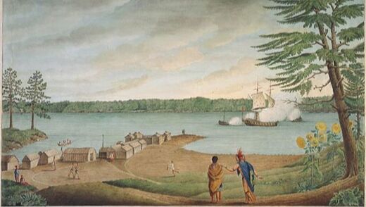
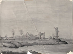
Point Au Baril
This watercolour shows Fort La Presentation (later Ogdensburg, N.Y.) exactly as it was on August 16, 1760, when six British row galleys attacked the French ship L'Outaouise (the "Ottawa") near the fort. It was painted by Thomas Davies, who occupied one of the galleys during the battle. The painting is held by the National Gallery of Canada. |
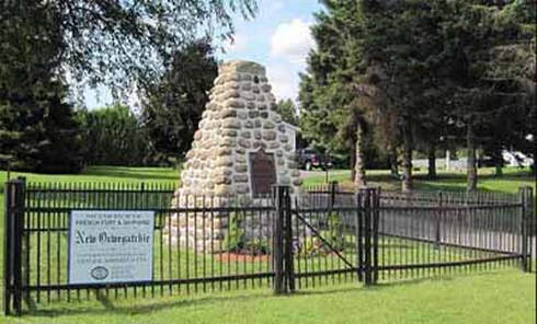
Point Au Baril Cairn
Commemorating battle between British and French warships at Point Au Baril. Located 1282 County Road 2, Maitland. Courtesy Parks Canada |
Immigrants Arrived in Grenville County
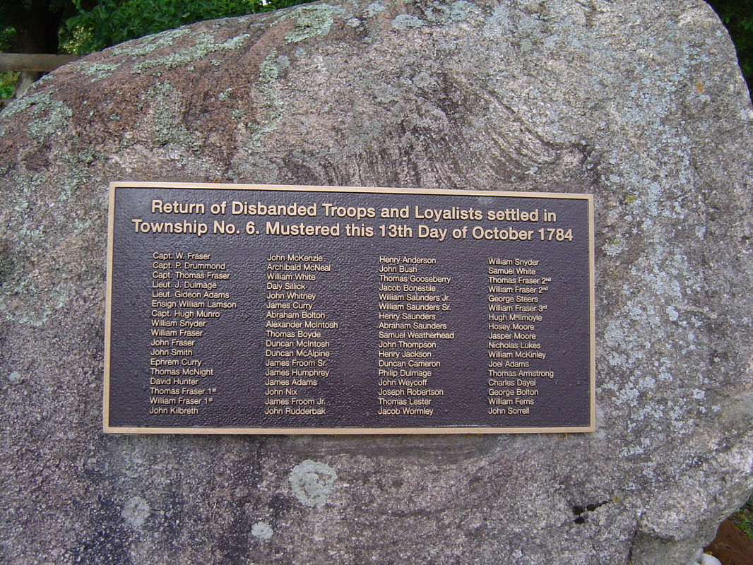
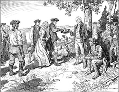
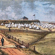
This area, part of the Province of Quebec, was sparsely occupied when the Loyalists came here. In 1783 surveyors laid out the townships of Edwardsburgh, Royal Township Number Six, and Augusta, Royal Township Number Seven, along the river for the men and women who maintained their loyalty to the British Crown. The first settlers, men who had served under Major Edward Jessup, arrived here in 1784 and were given lots in Augusta and Edwardsburgh Townships. They drew their lots and built temporary shelters, until they were able to establish more permanent homes. Crops were planted, mills were soon developed, and the first town site was established in 1789 at Johnstown. It was made a district town for the Eastern District, and a court house and gaol (jail) were built here in 1795. Oxford-on-Rideau was surveyed for settlement in 1791, Wolford in 1795, and South Gower in 1799.
|
|
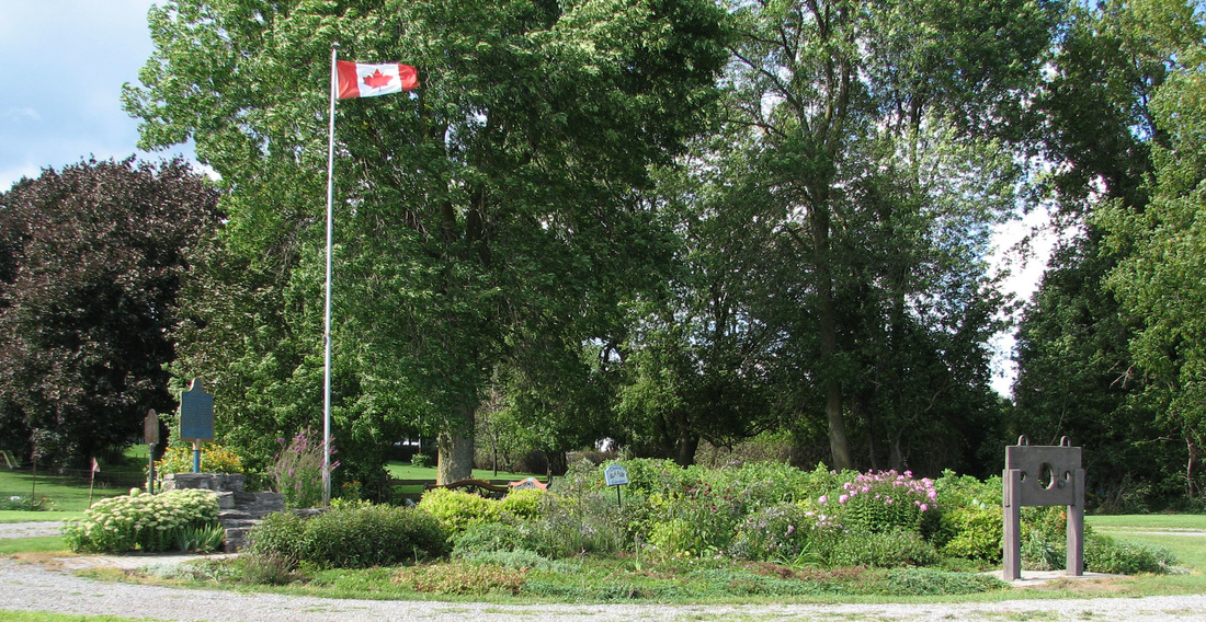
Millenium Park marks the location of the first Court House and Gaol (jail) in the Eastern District. Located on the north side of County Road 2 at Highway 16, Johnstown. (pillories were used for punishment of minor offences)
Fort Wellington
Fort Wellington was built in Prescott to protect the vessels travelling between Montreal
and Kingston on the St. Lawrence River from attacks by the Americans during the War of
812. It served as well during the Battle of the Windmill mentioned below, and in the
Fenian Raids in 1865. It was transferred to the Department of the Interior in 1923
and is now a National Historic Site.
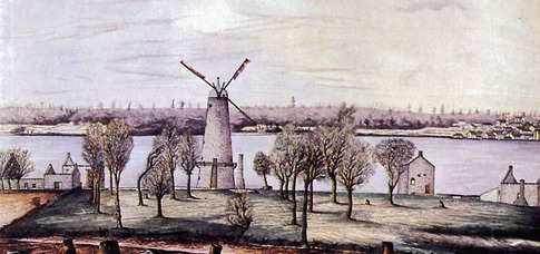
Battle of the Windmill
The Rebellion of 1837 in Upper Canada had far reaching effects in Grenville County. In November 1838 a force of about 300 American “Patriot Hunters” landed at the Windmill prepared to invade this area, capture Fort Wellington, and cut off the St. Lawrence River communications link. They firmly believed that the local residents would flock to their aid and join them in the fight for freedom. But instead, British troops and local militia, whose ranks swelled to about 2000, fought for four days against the invaders defeating them. Unfortunately during this period, forty-eight men were killed and eighty-nine wounded.
In the 1870s the mill was converted to a lighthouse, and today is preserved as a National Historic Site by Parks Canada and run by the Friends of the Windmill.
|
|
Over the years other groups have come to this beautiful section of Ontario including many English,
Irish, and Scottish families in the 1800s, and many Dutch in the 1950s. Today we are a mix of many
nationalities.
Irish, and Scottish families in the 1800s, and many Dutch in the 1950s. Today we are a mix of many
nationalities.
Boundary/Name Changes
This area was part of the Province of Quebec, and by 1788 Lord Dorchester, the Governor of Quebec, proclaimed that what is now the province of Ontario would be divided into four districts, Lunenburgh, Mecklenburgh, Nassau,and Hesse. Our area was part of the District of Lunenburg, named for the former principality of Brunswick-Lunenburg, part of the kingdom of Hanover. By the Constitutional Act of 1791, the province of Quebec was divided into the provinces of Upper and Lower Canada, and Lunenburg was a district within Upper Canada. Gov. John Graves Simcoe, Upper Canada’s first Lieutenant-Governor, renamed the districts in 1792 and formed them into nineteen counties. The name of our district became the Eastern District and we were in Grenville County. The county was named for William Wyndham Grenville, Secretary of State in 1790. The Eastern District encompassed the present counties of Stormont, Dundas, Glengarry, Prescott, Russell, Leeds, Grenville, and Carleton.
By 1798 the district’s name had changed once more, this time to the Johnstown District, which at that time included the counties of Leeds, Grenville, and Carleton (Lanark was part of Carleton as well). In 1841 through the Act of Union, Upper Canada and Lower Canada became Canada West and Canada East respectively. By 1849 the Johnstown District was made up of only Leeds and Grenville. The Townships of Oxford, Wolford, Marlborough, and Montague were originally considered as one township for municipal purposes and had one Council. They were recorded together in the early census records, and appear in the Grenville County land records up to the early 1840s. Marlborough appeared in Carleton County in 1842 and was incorporated as a township in Carleton in 1850; Montague transferred from the Johnstown District to the Bathurst District in 1842 and became part of Lanark County. It can be confusing when one tries to search for records as the boundaries and names changed so often.
When districts were abolished in 1850, the Johnstown District became the United Counties of Leeds and Grenville and still exists as such today. In 1867 the province of Ontario was established and our location was now Grenville County, Ontario. From 1850 until the 1990s Grenville County was composed of five townships: Wolford, Oxford-on-Rideau, and South Gower in the north, Augusta and Edwardsburgh in the south. Recently, with restructuring, these boundaries have been changed with the townships of South Gower, Oxford-on-Rideau, and the town of Kemptville amalgamating to form the township of North Grenville; the township of Wolford and the village of Merrickville joining to form the village of Merrickville-Wolford, and the township of Edwardsburgh and the village of Cardinal joining to form Edwardburgh/Cardnial. In 1867 at Confederation the Dominion of Canada, containing the provinces of Ontario, Quebec, Nova Scotia, and New Brunswick, was created.
|
|

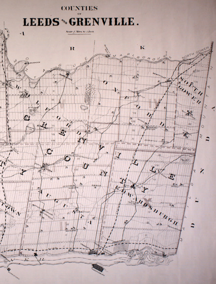
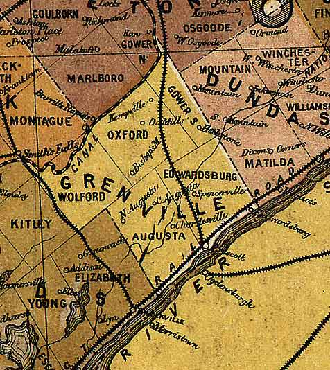
The following communities are located in Grenville County. Many small villages existed in the county and some had name changes over the years; their earlier names are listed in brackets. Some of these communities are just whistle stops now, but still retain evidence of their former occupants.
Augusta was first surveyed in 1783, incorporated in 1850. It includes the following communities: Algonquin, Centre Augusta, Charleville (Sebastopol), Domville (Henry's Corners), Garretton, Lord's Mills, Maitland (Pointe au Baril), Maynard, North Augusta (Bellamy's Mills), Prescott (inc. 1850), Roebuck, South Augusta, Throoptown.
Edwardsburgh was first surveyed in 1783, incorporated in 1850. It includes the following communities: Brouseville, Cardinal (inc. 1880), (Port Elgin, Munro's Point, Lewisville), Crystal Rock (Lime Kiln), Glen Smail, Groveton, Hyndman (Grant's Mills), Johnstown, Mainsville, Pittston, Prescott Junction, Shanly, Spencerville, Ventnor (Adams), Wexford.
Oxford-On-Rideau was first surveyed in 1791, incorporated in 1850. It includes the following communities: Acton's Corners, Bedell (Kempton), Bishop's Mills, Beckett's Landing, Burritt's Rapids, Christies Corners, East Oxford, Kemptville (inc. 1857), Millar's Corners, Newmanville, Oxford Mills, Oxford Station, Patterson's Corners, Swan Station.
South Gower was first surveyed in 1799, incorporated in 1834, and includes the following communities: Heckston (Archibald's Corners), Pelton's Corners, South Gower
Wolford was first surveyed in 1795, incorporated in 1850, and includes the following communities: Easton's Corners, Jasper (Olmstead's Mills, Irish Creek), Kilmarnock, Merrickville (inc. 1860) (Mirick's Mills).
NOTE: Recently with restructuring in 1999 and 2000 these boundaries have been changed as
follows:
North Grenville (formerly South Gower, Oxford-on-Rideau, Kemptville);
Merrickville-Wolford (formerly the Township of Wolford and the village of Merrickville;
Edwardsburgh/Cardinal (formerly the Township of Edwardsburgh and the village of Cardinal);
Augusta (no change);
Prescott (no change).
